 Translate
Introduction to Coastal Change Adaptation Plans (CCAP)
The Scottish Government produced interim guidance (SG2023) for the development of Coastal Change Adaptation Plans (CCAP) in February 2023.
This guidance recognises the ongoing and constant nature of change at the coast. It prompts us all to consider how we will need to adapt to that change in a sustainable manner by thinking about how we currently use and value the coast but also looking forward as to how we may need to respond and adapt to the increased rate of change due to Climate Change and, in particular, sea level rise.
Over the last thirty years sea level across Scotland has risen between two and three times faster than over the previous 100 years, with mean sea level anticipated to rise by between 0.30 to 1.16 m by 2100. This will, in many areas, result in an increased risk of flooding and an increased pressure on the coast for erosion.
While it is accepted that there are some uncertainties both in relation to the actual rate and timescale over which sea level rise will occur and how the coast will respond as well as the need to explore our own capacity for change, the guidance emphasises the need to start this process now. This includes:
- Raising the awareness of the challenges with individuals, communities, businesses, and local organisations to allow people to plan for change, working within the broader structure provided by the CCAP to shape their future.
- Informing Local Development Plans about future risk and to help identify where future coastal development should and should not be located.
- Helping to safeguard important and valued natural features, including those that can protect the coast, together with looking for opportunities for enhancing biodiversity and maintaining the mosaic of interconnected habitats.
- Taking a placemaking approach to deliver, as far as possible, multiple benefits across the whole range of interest associated with the coastal zone.
Critically, the guidance recognises the ongoing nature of coastal management. The aim is to develop CCAPs based on the information already collated within Shoreline Management Plans (SMPs) and building on the information developed through further local studies alongside national data sets such as the Dynamic Coast webmaps.
However, as part of the CCAP process, the aim is to critically examine how we currently manage the coast and to challenge current practice from a longer-term, broader scale perspective. This should ensure that future challenges are identified and that short term decisions do not constrain future opportunities.
The Local CCA Plans identify policies, triggers, and actions to help us all to plan and respond to the changing shoreline. A CCAP technical report document contains more detailed information.
National Guidance - Principles and Objectives
The national guidance does not prescribe exactly how local authorities should develop their Coastal Change Adaptation Plans (CCAP). Instead, it provides guidance as to what they should seek to achieve and how it might be delivered. Importantly, the national guidance recognises that “one size does not fit all”. The guidance recognises the need to maintain flexibility for appropriate local and regional CCAP delivery structures to emerge and also recognises that CCAPs need to reflect the complexity of local areas.
However, the guidance sets clear principles and objectives that the CCAP should work within.
Core Principles
- to create a vision for well-adapted and resilient management, properly integrated into other policies by taking a more land use planning approach, and avoiding locking-in future generations to unsustainable actions as sea levels are expected to continue to rise well beyond the end of this century;
- to seek opportunities to support and regenerate communities and address inequalities. In particular, policy should anticipate that changes to property protection and property values will increasingly come into focus as adaptation pathways are developed; and
- to deliver multiple benefits (for example economic, environmental or amenity enhancements), and to promote sustainable infrastructure and work to preserve natural features and ecosystems.
Key Objectives
In line with the core principles the following overall objectives of the CCAP are:
- To promote the resilience of our natural coastline and begin the process of adaptation to climate change;
- To set out a process for a proactive approach to coastal adaptation planning that will maximise opportunities and minimise risk from climate change impacts;
- To ensure our collective coastal adaptation journey starts now; and
- To support local authorities to begin the process.
Approach to developing North Ayrshire’s CCAP
The North Ayrshire coastline covers a length of some 150km of shoreline, including areas of the mainland alongside the principal islands of Great Cumbrae and Arran. Within this length of coast, there is a large variation in the coastal character. In coastal towns and larger villages, there are significant lengths of man-made protection. Elsewhere, small settlements and many small ports and local harbours are all set within broader areas of natural shoreline.
There is, therefore, a clear need to adapt the level of detail provided by the CCAP to reflect the local nature of the coastline in any location and to help manage specific local issues. The current Ayrshire Shoreline Management Plan (SMP) (RPS, 2018) provides the initial background and structure to the size and shape of future CCAP study areas. The SMP identifies broad interdependencies throughout the coastline and provides the opportunity to focus in more detail on individual areas without having unexpected consequences elsewhere.
Given this, the approach is to develop a series of Local CCAPs throughout North Ayrshire. This will be an ongoing process. The intent is to develop these Local CCAPs in a consistent format around parts of the coastline, guided by the policy units identified in the Shoreline Management Plan (SMP). Ultimately, this will allow the collation of these Local CCAPs into one CCAP for North Ayrshire.
This plan
This plan sets out the overall approach being taken to develop the North Ayrshire CCAP, as discussed above. As Local CCAPs are developed, additional sections will be added to summarise and record the emerging policies, actions, and decision-making frameworks for each local area.
The development of Local CCAPs will include a review of the conclusions of the SMP and it is intended that the CCAP summary documents will replace the SMP for each local area.
Two detailed local studies at Stevenston and Irvine have been completed to start this process and to develop Local CCAPs covering these areas. The two areas, so far included are for:
- The Sandylands Promenade and Stevenston Beach (Local CCAP 6c2.B), and
- Irvine Harbour to Gailes Burn (Local CCAP 6c2.D)
The Sandylands Promenade and Stevenston Beach

General description
The Sandylands Promenade and Stevenston Beach, covering some 2.5km of coastline, is formed as an effectively artificial embayment formed by the historic development of the southern Saltcoats Harbour arm, constructed out over a natural rock outcrop, and Stevenston Point, which was formed over the last century by tipping of mining waste.
The area is covered by two relatively distinct, although interconnected, sections.
The Sandylands Promenade, comprises a major sea wall protecting the railway line and providing a defence to the lower lying land behind. The wall is fronted by a low intertidal foreshore with a thin veneer of sand. Currently, the wall and promenade suffer significant overtopping during major storm events
The Stevenston Beach and Dunes, comprises an area of natural dunes extending back into an area of important open space. The dunes and open space are designated as a Local Nature Reserve (LNR) and a Local Nature Conservation Site (LNCS) highlighting the important ecological value associated with the area. The dunes are currently eroding and opportunities for dune restoration are limited. There is also significant human trampling causing damage to the dunes. As the dunes have eroded, this has exposed the toe of an old mining waste spoil heap and this is also eroding. The area is cut by the Stevenston Burn, with the Burn running back into the town of Stevenston. The channel of the Burn across the foreshore has been subject of significant change, influencing and being influenced by coastal change.
A critical feature of the area is the transition between the hard defence along the promenade and the natural section of dunes, with an increasing challenge to maintain an important slipway and to acceptably manage the transition between hard and soft shorelines.
The SMP context

The SMP (2018) defined the area within the general sub-cell 6c2, with a further division of the wider area into four SMP Policy Units. The Local CCAP area is contained within SMP Policy Unit 6c2.1.
The general policy for this unit is for Holding the Line (HTL) over the three epochs considered by the SMP. However, there was an important caveat that, with respect to Stevenston Beach, the intent was to manage erosion of the dunes using soft engineering approaches.
In reviewing the SMP, as part of developing the Local CCAP, it has been agreed that the SMP Policy Unit should be further sub-divided into two CCAP Zones:
- 6c2.A, covering Ardrossan and Saltcoats Harbour
- 6c2.B, covering this Local CCAP area of the Sandylands Promenade and Stevenston Beach
This retains the ability to consider the important broader scale interaction across the whole Local CCAP area, with the definition of two CCAP Policy Units 6c2.B1 and 6c2.B2 reflecting the local characteristics of each local area.
Coastal Change
The whole area has been subject to historical erosion, resulting in the loss of natural beach where the shoreline is now defended by a seawall and promenade. The artificial development of Stevenston Point has allowed some retention of sediment over the foreshore resulting in lower rates of erosion of the dunes at the eastern end of the study area. The construction of the defence along the promenade has reduced the supply of sediment to the dunes and increased erosion has occurred to the dunes immediately to the east of the Promenade. As the dune line has eroded, this has exposed the toe of the historic spoil heap and this is now acting to partially control the alignment of the frontage.
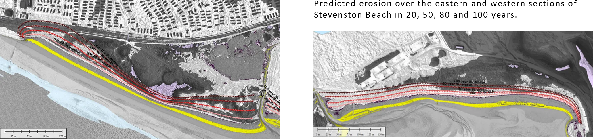
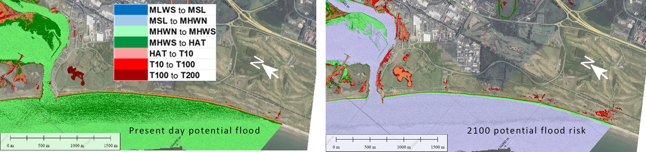
With sea level rise the rate of erosion to the dunes will increase. The predicted erosion distances over the next 100 years are shown in the images below. These erosion lines are based on the UKCP18 8.5 (95 percentile) sea level rise scenario, as recommended in the national guidance for CCAPs.
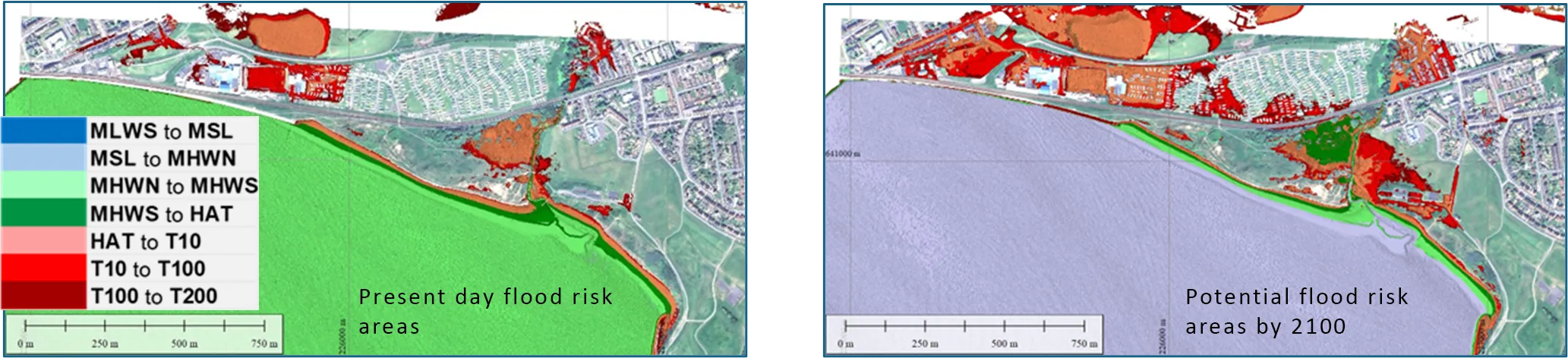
Currently, there is relatively low flood risk within the area, although the promenade and railway are subject to severe wave overtopping during major storms. With sea level rise, larger areas will be at potential risk. This change is shown by comparing the current and future (2100) relative land levels with respect to coastal water levels. The risk of overtopping of the Promenade wall will similarly increase.
Management Issues
- The risk to the railway line and the hinterland area inland of the railway.
- The potential increased flood risk to property within Saltcoats and Stevenston.
- The potential longer-term risk to the railway line due failure of the defence and erosion of the dunes to the east.
- The risk to the active travel route behind the dunes and along the Promenade.
- The ongoing erosion and coastal change to the dunes and the potential impact on the recreational use of the area.
- The need to maintain the open space use of the area.
- The management of the transition between the hard defence of the Promenade and the natural dunes.
- The ongoing erosion of the spoil heap, the potential release of contamination, and the impact on the use of the area from coastal change.
- The important landscape and natural environment of the area.
Policy update
The overall intent of the Local CCAP recognises the need to maintain the defence of the Sandylands Promenade (subject to ongoing funding arrangements) to secure important strategic and local assets and infrastructure. Notwithstanding the increasing pressure on this defence, particularly with sea level rise, it is considered that this can be undertaken in a sustainable manner. Consideration needs to be given to possible alternative forms of defence. Typically, this would need to be considered over the next 20 years as the basic ‘Do Minimum’ approach becomes increasingly difficult to sustain. Over the long-term (100 years and beyond), continuing to defend may require significantly greater investment. This longer-term issue will require ongoing review, particularly as longer-term planning is undertaken in relation to the railway line.
Over the Stevenston Beach area, the intent is to generally allow natural ongoing coastal change. As part of this, the intent is to develop, with the community and stakeholders, a modified structure for managing access along and through the dunes. The aim of this is to minimise the impact on the dunes while still maintaining the important use and recreational value of the area. This approach will recognise the ongoing change to the dunes and will be adapted as part of ongoing management.
The plan recognises and discusses the important interaction between the hard defence to the Promenade and the natural dune system. The intent of the plan is to manage this area without automatically extending the hard defences further to the east. Any new defences in this location u would need to be carefully considered.
The specific polices defined by the local CCAP are set out in the table below.
| Local CCAP Policy Unit | Short term policy | Longer term policy | Notes |
|---|---|---|---|
| 6c2.B1 - Sandylands Promenade | HTEL | HTEL | Need to develop medium to longer term approach. |
| 6c2.B2 - Stevenston Beach | MR | MR | Ongoing adaption to coastal change with local intervention. |
The Local CCAP updates and provides greater clarity and detail with respect to management of individual sections of the coast as compared to the single Policy Unit defined by the SMP.
The approach to management, set out in the Local CCAP, reinforces the need to consider mitigation measures discussed in the SMP, in:
- Considering alternative options for the management of Sandylands Promenade specifically in terms of its interaction with the wider area.
- Considering management of the transition between the hard defence line and the natural dunes to minimise the need to further extend the hard defences to the east if possible.
- Allowing a more adaptive approach to management of potential contamination arising from erosion of the spoil heap.
- Allowing the natural evolution of the dunes, while encouraging development of a coherent Access Management Plan for the area.
Alongside this, the CCAP has identified the potential opportunity for further habitat enhancement in providing the policy structure for revision of the Stevenston Beach Local Nature Reserve Management Plan and in identifying the potential for future change to the marsh area associated with the Stevenston Burn.
Critical decisions
The following Dynamic Adaptive Pathway diagram highlights where critical decisions will be needed in developing the CCAP into the future. The need for decisions are driven by anticipated Trigger Points relating to the management of defences and risk or in anticipation of natural coastal change.

Action Plan
The following actions are required in delivery of the Local CCAP
| Action | Area | Description | Notes | Timescale Year (trigger) |
|---|---|---|---|---|
| 1 | Sandylands Promenade | Continue to maintain existing hard defences. | Secures defence over the short term, allowing consideration of longer term options. | 1 (20) |
| 2 | Sandylands Promenade | Highlight and raise awareness of short to medium-term risk and support preparation of option planning. | Ensures continuity of management across the wider area. | 1 (20) |
| 3 | Sandylands Promenade | Raise awareness of very long-term sustainability issues. | Maintain long term awareness of possible issues in relation to review of forward planning. | 20 (100) |
| 4 | Stevenston Beach and transition | Ongoing discussion with Network Rail and statutory stakeholders with respect to transition area. | Determines further development of specific coastal management options. | 1 (5 to 10) |
| 5 | Stevenston Beach and transition | Undertake further development of options for transition area. | Detailed option study. | 1 (5 to 10) |
| 6 | Stevenston Beach and transition | Undertake short term measures to sustain slipway. | Needs to be integrated with longer-term options for management of transition. | 2 (5 to 10) |
| 7 | Stevenston Beach and transition | Ongoing monitoring of spoil heap, with potential need for further investigations. | Longer term planning of local options for management of spoil heap. | 3 (15) |
| 8 | Stevenston Beach and transition | Develop and implement improved access point associated with outfall. | Improves access and management of change. Also exemplifies potential options for general access management. | 1 (3) |
| 9 | Stevenston Beach and transition | Further discussion and development of access management plan with community. | Progresses development of overall access plan, allowing opportunity for funding. | 2 (5) |
| 10 | Broader Area | Ongoing monitoring. | Allows review of trigger points and informs decisions. | Ongoing |
Irvine Harbour to Gailes Burn
General description
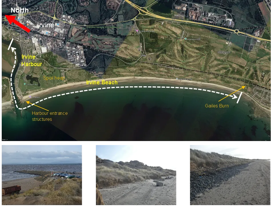
The Local CCAP area includes two quite distinct areas covering Irvine Harbour, within and running along the southern side of the Irvine/Garnock Estuary and running out to the Harbour entrance structures, and Irvine Beach extending through from the Harbour Pier to Gailes Burn. The total length of the area is around 6km, with around 4.5km of that being the main open beach section.
The Harbour comprises a series of vertical quay walls, with property built to the quay at the upstream end but, more generally, with a road running directly behind the quay with properties, car parks and open ground further inland. North Ayrshire Council has aspirations to further enhance the Harbourside area and have developed a Great Harbour Masterplan. The masterplan includes the development of the maritime mile waterfront walkway and three activity hubs.
Irvine beach area comprises a relatively wide sandy beach, stretching south towards Troon and is largely backed by a dune system, although the form and behaviour of the dune and hinterland use varies along its length. The northern section of the beach has a long industrial history and, most obviously, the historic past is evidenced in this area by the massive spoil heap some 500m south of the harbour, with the toe of the mound now becoming exposed by erosion. Further south where the toe dune has been eroded, there are further signs of the industrial heritage, with remnants of fencing and buildings now being exposed. Beyond this area the slightly more stable dune is backed by golf courses with features of the golf course relatively close to the back of the dune.
Within the area of the open coast is the West Gailes SSSI, which is focused on the dunes and extends back across part of the golf courses. A further SSSI - the Bogside Flats SSSI - abuts the harbour but principally extends back to encompass the larger area of the Garnock Estuary.
The main northern area of Irvine Beach provides an extremely well-used open space with a high amenity and recreational value that is linked through to the important open space behind the harbour and the integrated use and appeal of the wider area.
The SMP context
The SMP (2018) defined the area within the general sub-cell 6c2, with a further division of the wider area into four SMP Policy Units. The Local CCAP area is contained within SMP Policy Unit 6c2.3.
The general policy for this unit is for Holding the Line (HTL) over the three epochs considered by the SMP. However, there was an important caveat that, with respect to Irvine Beach, the intent was to manage erosion of the dunes using soft engineering approaches.
In reviewing the SMP, as apart of developing the Local CCAP, the extent of this SMP Policy Unit should be retained as:
- 6c2.D, covering Irvine Harbour to Gailes Burn.
However, this Local CCAP area is now considered as two CCAP Policy Units: 6c2.D1 (Irvine Harbour) and 6c2.D2 (Irvine Beach) reflecting the local characteristics of each local area.
Coastal Change
The harbour does to some extent constrain and fix the general curve of the Irvine channel although some slight pressure for bed erosion in this area may be expected. There are no reports of undermining to this area at present. Currently the structures along the harbour and at the harbour entrance have been suitably maintained. The harbour entrance structures do impose significant control on the natural change at the mouth of the estuary and maintaining these structures is considered to be a sustainable action.
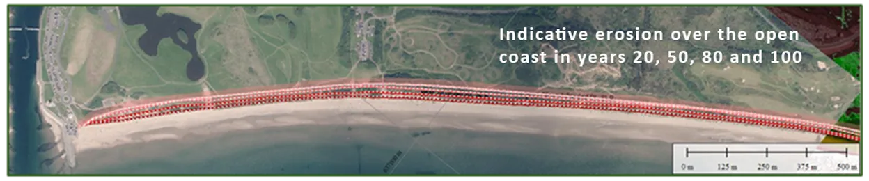
Generally, there has been long-term persistent erosion along much of the open coast, with the dunes remaining slightly more stable towards the West Gailes area. Typically, over the northern section, recent erosion has been in the order of 0.4m/yr. This erosion has exposed the toe of the major Spoil Heap which has been protected by gabion baskets which are now failing. An assessment of future erosion distances is shown in the figure below.
Currently there is little direct flood risk across the area. With sea level rise, some areas will be at increased potential risk, particularly in the area of the harbour. This predicted change is shown by comparing the current and future (2100) relative land levels with respect to coastal water levels.
Management Issues
- The potential risk to the use and regeneration of the harbour area with sea level rise.
- The risk to the active travel routes and open space behind the dunes and further south to potential users of the golf courses.
- The ongoing erosion and coastal change to the dunes and the increased pressure on the dunes from excessive and ad hoc use of the dunes.
- The ongoing erosion of the spoil heap and the potential release of contamination.
- The important landscape and natural environment of the area, specifically the ongoing change to the West Gailes SSSI.
Policy Update
The Local CCAP has sub-divided the coast into two policy units as these two units have very different characteristics and therefore require different polices. However, grouping both units under one Local CCAP reflects and helps to raise awareness about the significant interdependencies particularly in relation to the overall use and access along the coast.
The intent of the Local CCAP is to maintain the use of the harbour area sustaining the specific character and leaving room for regeneration opportunities. The CCAP raises the awareness of potential longer-term increased flood risk with sea level rise and prompts consideration of this future risk when developing detailed plans for the area. The physical trigger point for adaptation might not occur for 50 years.
With respect to the open coast unit, it is proposed that the CCAP policy is revised to one of Managed Realignment. This better reflects and clarifies the implications of the previous caveated policy set by the SMP. The intent of the policy is to sustain as far as possible the natural development of the dunes. Over the northern Irvine Beach this requires development of an Access Management Plan, which should seek to minimise interventions at the dune face.
Over the critical spoil heap frontage, the final approach to management would need to be determined based on further investigation of the nature of material contained within the spoil heap. The underlying intent is to allow, as far as possible and permissible, the natural development at the shoreline. However, the policy also recognises that there may be a need for new hard engineering works.
Further south, the overall aim is to allow the natural development and roll back of the dunes. This would support the management intent set out in the SSSI designation. This policy recognises that there may, therefore, be a need for some adaptation of the golf courses.
| Local CCAP Policy Unit | Short term policy | Longer term policy | Notes |
|---|---|---|---|
| 6c2.D1 - Irvine Harbour | HTEL | HTEL | Consideration of long-term adaption. |
| 6c2.D2 - Irvine Beach to Gailes Burn | MR | MR | Ongoing adaption to coastal change with local intervention and management plans. |
The Local CCAP reinforces the need to consider mitigation measures discussed in the SMP.
- With respect to the harbour, the Local CCAP recognises the need to address the increased flood risk with sea level rise and to consider the potential impact on the landscape and use of the area.
- Further investigation is required into the nature of material contained within the spoil heap and the potential impact that ongoing erosion of the spoil heap would have on the marine environment. This would be taken forward through development of the Local CCAP.
- Associated with the above, the Local CCAP identifies the need to consider and mitigate the potential influence any management would have on sediment supply along the shoreline, with particular reference the potential impacts on the West Gailes SSSI.
- More generally, the overall intent to allow ongoing natural development of the dunes would maintain sediment supply along the frontage minimising the impact on the West Gailes SSSI.
- The Local CCAP recommends the development of specific management plans for adaptation of the West Gailes area.
Furthermore, developing the Access Management Plan aims to balance the need to maintain important and values use of the open coast alongside sustaining a healthy dune system.
Critical Decisions
The following Dynamic Adaptive Pathway diagram highlights where critical decisions will be needed in developing the CCAP into the future. The need for decisions are drive by anticipated Trigger Points relating to management of defences and risk or in anticipation of natural coastal change.

Action Plan
The following actions are required in delivery of the local CCAP
| Action | Area | Description | Notes | Timescale Year (trigger) |
|---|---|---|---|---|
| 1 | Irvine Harbour | Continue to maintain harbour defences. | Secures defence over the short to medium term, allowing consideration of longer-term options. | 1 (50) |
| 2 | Irvine Harbour | Highlight and raise awareness of longer-term flood risk. | Allows integration of potential future risk within current planning. | 1 (50) |
| 3 | Irvine Beach and Spoil Heap | Detailed investigation of potential contamination. | Determines further development of specific coastal management options. | 1 (5 to 10) |
| 4 | Irvine Beach and Spoil Heap | Develop options for coastal management to Spoil Heap. | Detailed option study. | 3 (5 to 10) |
| 5 | Irvine Beach and Spoil Heap | Detailed development of access plan. Working with partners to agree position of access points and approach to ongoing management. | Needs to take account of access management along spoil heap area. | 3 (5) |
| 6 | Broader Area | Raise awareness of potential need for adaptation to golf course frontages. | Establish initial contact and discuss how future planning may be facilitated. | 1 (20) |
| 7 | Broader Area | Ongoing monitoring. | Allows review of trigger points and informs decisions. | Ongoing |